

PRESS NAME OF TOWN TO SEE PICTURES
↓↓
↑↑
PRESS NAME OF TOWN TO SEE PICTURES


Welcome to my web site!
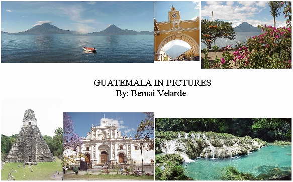
This web site is filled with pictures of beautiful Guatemala. From the modern Capital City of Guatemala to the colonial Spanish style towns, to the traditional native Mayan and unexplored rivers, lakes and caves. I invite you to travel through this marvelous country through the lens of my camera. It is a fascinating country rich in traditions, folklore and customs. I have enjoyed taking these pictures and I hope that you will enjoy seeing them. Come back as often as you please. I am leaving Guatemala after five years so I will not be able to up-date this site, however; I will continue to up-date the favorite sections, with links to other sites of Guatemala.
Background:
|
Guatemala with a population of more than 14,600,000 persons is the largest economy in Central America, accounting for about one-third of regional Gross Domestic Product. The economy is predominantly agricultural, with more than half of the country's labor force engaged in farming. Guatemalan society is sharply segmented, with highly skewed income and land distribution. Nearly half of the population are of Mayan origin, living in poverty and at the margins of modern society. Poverty is mostly concentrated in the rural areas where most of the indigenous groups live. It afflicts over seventy five percent (75%) of the population, eighty-six percent (86%) of the rural population, and seventy percent (70%) of female-headed households (forty-nine percent (49%) of which are in extreme poverty). The population with the highest ten-percent (10%) income receives 46% of the total income while forty-percent (40%) of the poorest population receive only 7.9% of the total income. You will easily see this reflection, in the pictures of this website. | |
|
One of the immediate challenges facing the Government of Guatemala is to increase economic opportunities for the returning and displaced populations in order to rebuild the economic and social fabric after thirty six (36) years of internal conflict. The Peace Accord lays the foundation and the commitments of the Government of Guatemala to promote sustainable and equitable development for its people. The way to peace and prosperity is difficult and much remains to be done. |
Flag of Guatemala
Click on Flag to hear the Guatemalan National Anthem
Administrative Departments of Guatemala:
|
Administratively Guatemala is divided into 22 departments as follows: Alta Verapaz, Baja Verapaz, Chimaltenango, Chiquimula, El Progreso, Escuintla, Guatemala, Huehuetenango, Izabal, Jalapa, Jutiapa, Peten, Quetzaltenango, Quiche, Retalhuleu, Sacatepequez, San Marcos, Santa Rosa, Solola, Suchitepequez, Totonicapan, Zacapa Guatemala is surrounded by four countries, Mexico, Belize, Honduras and, El Salvador. |
|
Maps of Guatemala |
General Statistics
|
Area: 108,889 sq km (42,042 sq miles)...slightly smaller than Tennessee | |
|
Population: 14,655,189 (July 2005 est.) | |
|
Capital City: Guatemala City | |
|
Language: Spanish and 21 major Mayan languages | |
|
President: Oscar Rafael Berger Perdomo | |
|
Government: Democratically elected every 4 years | |
|
Independence Day: September 15, 1821 | |
|
Religion: Roman Catholic, Protestant, Mayan-Christian | |
|
Electricity: 110 volts AC, 60 Hz | |
|
Telephone Country Code: 502 | |
|
Number of Phones: 846,000 (2002) | |
|
Number of Cellular Phones: 1,577,100 (2002) | |
|
Internet Users: 400,000 (2002) | |
|
Inflation: 7.2% (2004) | |
|
Exchange Rate: 7.86 (12/31/01) | |
|
Birth Rate: 34.11 births/1,000 population (2005 est.) | |
|
Death Rate: 6.81 deaths/1,000 population (2005 est.) | |
|
Population Below Poverty Line: 60% (2000 est.) | |
|
Number of Banks: 31 (July 2002) | |
|
Number of Bank Branches: 1,233 (July 2002) |
![]()
Press the names of the towns on the left margin of this page to see the pictures.
![]()
Webmaster: Bernie Velarde Drop me an e-mail and tell me what you think.
Last updated 07/14/05